|
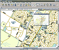
Ozi Explorer interface
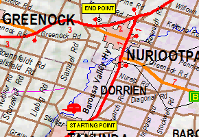
Waypoints in Ozi Explorer - it's easy to replace the
auto numbered name with descriptive text.
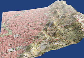
An image of the hills to the west of Adelaide from
Ozi Explorer 3D showing the atmospheric effect. This
image used 9sec DEM height data.
|
Ozi Explorer
GPS Mapping Software (Full
Edition)
(includes OziExplorer 3D demo)
A great Australian product which is also widely used
outside of this country, Ozi Explorer will work with
data captured from the most populars brands of GPS
including Garmin, Magellan, Silva, Lowrance and
others.
Plan your trips in advance and upload waypoints and
routes to your GPS. Add notes and features to the maps
on your computer to aid you in your travels.
When a laptop is connected to a GPS, Ozi Explorer
can be used to show an on-screen display of your
current position. You can follow a previously
calculated route or update your journey's progress in
real time.
Utilise Ozi Explorer with maps you have prepared
yourself or with professional map data on disc such as
NATMAP Raster Mosaic and Fullers
Adelaide
and SA Country Towns.
Some maps on disc come with Ozi Explorer Lite mainly
for map viewing but the full version of the software
offers a far greater range of features.
GPS connectivity is only
available with
the
full edition of Ozi Explorer.
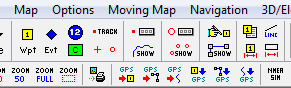
Ozi Explorer has an extensive toolbar menu with
almost everything you might want a mouse click away.
Detailed "tooltips" help you quickly learn what each
button does.
Don't forget: If you are new to Ozi
Explorer we run an Introduction
to
Ozi Explorer course. Contact us via
the details in the header and footer on each page of
this site to book your place in the next one.
For the latest price on OziExplorer visit
our SHOPPING
CART
Program Extensions
Ozi Explorer CE is
available for Windows mobile devices for AUD$42.50.
An Android version for tablets and smart
phones is under development.
These are considered extensions of the
main program and are purchased separately to but not in
place of the main program. The user might do their map
preparation work on their desktop or laptop and then
transfer the data and maps to their mobile device. Some
functions such as setting way points and tracks can be
done in CE or Android but these versions don't replicate
all of Ozi Explorer's capabilities.
Ozi Explorer 3D comes
with the main program as a limited function demo . It
requires DEM data (digital elevation model) to
work. It needs to be licensed for full
functionality AUD$42.50.
|
City Navigator Australia & New Zealand.
Garmin TOPO Australia & New Zealand
For the latest prices visit the
SHOPPING
CART
|
Garmin Map Data
Garmin map data once came on a disc but these days it
arrives on an SD card or via download.
City Navigator
City Navigator lets you navigate the streets with
confidence. This product provides detailed road maps of
nearly 1.3 million km of roads, including motorways,
national and regional thoroughfares and local roads
throughout Australia and New Zealand. It also displays
more than 640,000 points of interest throughout the
countries, including restaurants, petrol stations,
lodging, attractions and railways.
Gives turn-by-turn directions with street names (eg:
"Turn right on Main Street") on compatible devices so
you can navigate to any address or intersection.
Includes navigational features, such as turn
restrictions, roundabout guidance and speed categories.
Contains traffic data for compatible devices that use
traffic receivers.
For the latest prices visit the SHOPPING
CART
Garmin TOPO Australia & New Zealand
Get enhanced topographic detail on your compatible
device whether you're in the outback or on a main
boulevard in the city. This map provides a wide array of
topographic information from terrain contours,
elevations and summits to coverage of perennial and
intermittent lakes, rivers and streams in Australia and
New Zealand. Features include:
-
Provides topographic terrain contours at 20m
intervals, approximating 1:100K maps for Australia
and 1:50K maps for New Zealand, plus summit points
for detailed lay of the land.
-
Shows land cover and complete coverage of
Department of Conservation huts, camps and tracks
for New Zealand, as well as LINZ 50K map sheet names
and boundaries for New Zealand.
-
Contains tracks, outback trails, 4WD destinations
and hydrographic features, including lake/river
shorelines and perennial and seasonal streams.
-
Includes famous outback routes, such as Birdsville,
Strezelecki, Oodnadatta and Canning Stock.
-
Provides elevation profile on compatible devices so
you can estimate terrain difficulty.
-
Displays national, state and local parks, forests
and reserve areas.
For the latest prices visit the SHOPPING
CART
LMT - Lifetime map updates
are downloaded from Garmin's website.
|
For our customers:
 |
Map
Data from gpsShop and The Map Shop
We created our own data on an SD card including 1:250k
topo mapping of Australia as well as additional maps of
South Australia, parts of South East Asia and more.
This card is only available to people who bought their
GPS from the gpsShop or The
Map Shop. It is available to our other GPS
customers for only AUD$50.
|