Fullers on CD
Fullers 80th YEAR EditionFullers Adelaide & Country SA Street Directory started in 1927 as a series of 9 folded maps centred on Adelaide and the surrounding suburbs. The coverage provided in the directory has expanded with the city and beyond to cover most of the state of South Australia. It is not just the only Adelaide Street Directory fully produced in South Australia it is the only Country SA Street Directory produced in South Australia - and you get it all in the same volume. This CD product utilises the latest Fullers data which intoduces a number of towns and localities for the first time. The contents of this CD remains the property of Fullers Maps Pty Ltd and is licensed for personal use only. |
|
CONTENTS
The gif images and map files contained on this CD have been organised into several folders for your convenience. Most file names adopt the 8 character only convention therefore some files using place names are truncated and/or abbreviated. They are grouped under the following headings and can be located in the folder on the cd labelled "oziexplorer_maps".
STREET LISTINGS
Although we do not at this stage supply a street listing with coordinates suitable for use within OziExplorer, databases provided by users are available through the OziExplorer users group. Such forums can provide useful information and advice for users.
Detailed maps of both the Adelaide CBD and North Adelaide can be found in this section as well as regional maps constructed from the index pages of the hard copy edition of Fullers Adelaide and Country SA Street Directory.
country_roads
Available for the first time on this CD
The 10 regional reference maps from the last printed edition and CD have been replaced with a more extensive and detailed 50 page regional road atlas style section based on the Australian Government 1:250 000 map data. These are ready to use in OziExplorer.
index_map
This map is designed to be used as an index map within OziExplorer for the greater Adelaide metropolitan area.
metro_blocks
These maps and images of the greater metropolitan area of Adelaide have been constructed by combining complete directory pages into larger blocks. As many as 15 pages from the Fullers Adelaide and Country SA Street Directory have been assembled per individual gif and its map file.
Images are up to 6mb in size and they provide the complete detail of the Fullers maps in a more convenient continuous format. Usage of these maps rather than those found in the "pages" folder reduces the frequency of OziExplorer requesting an adjacent map.
To ensure coverage of the greater metropolitan area some isolated pages and towns have been replicated in this folder. Southern Fleurieu Peninsula locations can be found in the "towns" folder.
NOTE:An overview of these maps can be viewed when using the "fullers_metro_index" map found in the "index_map" folder.
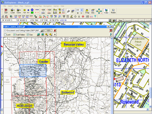
Screen capture showing the "fullers_metro_index" map being used in Ozi Explorer.
pages
This folder comprises 106 individual maps from pages 1 to 102 of the Fullers Adelaide and Country SA Street Directory.
NOTE:An overview of these maps can be viewed when using the "fullers_metro_index" map found in the "index_map" folder.
towns
Included in this folder are 100 .map and 100 .gif files representing many South Australian towns. Most of these are from pages 201 to 251 of the Fullers Adelaide and Country SA Street Directory. Others, such as some Adelaide Hills and Fleurieu Peninsula communities, are from the metropolitan section of the street directory (pages 1 to 102) but can be found in the "Towns" folder on this Fullers CD.
Two additional .gifs; Roxby Downs and Andamooka are provided although
we are unable to include the relevant .map files at this stage. If you have
set up either of these maps with viable co-ordinates in OziExplorer
and want to share that information with other users you can email your .map
file to us at:
mercator@mapshop.net.au
We will seek to confirm its accuracy and then make it available via the Fullers website and include it on the CD in the future.
Installation
The Fullers Adelaide and South Australian Country Towns Street Directory on CD does not use an installation utility program. Simply copy the desired folders(s) or their contents to the required location on your computer. You can also read the Fullers data direct from the disc if you prefer.
You can also use OziExplorer to import the maps for you. The process is outlined below.
Importing new files
Open OziExplorer then select "File / Import Map / OziExplorer Map files (*.map) on CD".
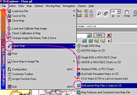
This will produce a requester where you can indicate the "Source" and "Destination" paths for your Fullers *.map files. When satisfied with your selections click the "Import" button. Your new files and their position on your computer will nnow be automatically acknowledged by OziExplorer.
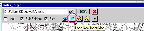
To load the Fullers index map
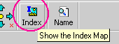
When you next use OziExplorer open the the index map requester/display by clicking the "Show the Index Map" button and then direct the "Load New Index Map" to the required index map and folder.
Use the "The Search Path for Maps to Outline on Index Map" button to select the location of the Fullers data.
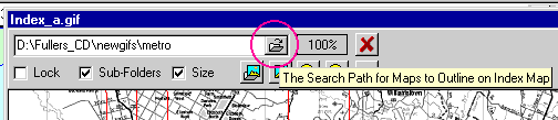
Once the index map and the map path have been selected r-click on in the index map window and select "Refresh Maps". You may need to roll your mouse over the index map window to get the map outline boxes to appear.
If in doubt consult your OziExplorer documentation!
ANTI-ALIASING - New for this CD edition
Anti-aliasing is a process where visual information for use on computer screens is made more legible by creating a blend zone between adjacent blocks of colour. It is particularly useful with text as it reduces the pixelated "boxiness" around the edges.

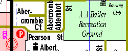
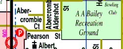
The line on the right is anti-aliased while the left line isn't. (5 times enlarged)
Some users expressed concerns regarding the lack of anti-aliasing in previous editions of the Fullers on CD. In this release we have utilised a new process for exporting map data to images that allows us to incorporate a degree of anti-aliasing. Although the image dimensions in pixels remain the same, the data complexity is increased and so the image sizes in kilobytes have increased.
Disclaimer
Whilst every care has been taken in the production of the maps on this CD the publishers cannot accept responsibility for errors or omissions.
The portrayal of a road or track on these maps is not necessarily an evidence of public right of way.
License
The contents of this CD remains the property of Fullers Maps Pty Ltd and is licensed for personal use only. Personal use does not include publishing to the web, digital copy, hard copy, digital network or any other mode of general distribution.
Contact
The assistance of users is requested in the notification of errors, omissions or changes that are observed. Persons doing so are offered a 25% off the recommended retail price of the subsequent printed edition of the Fullers Adelaide and South Australian Country Towns Street Directory if the advice or assistance is the original notification.
If you have created your own .map file for Andamooka or Roxby Downs based on the Fullers .gif images on this CD or believe any of our map file coordinates are inaccurate we would be pleased to hear from you.
Please contact us with any suggestions you may have for improving this product.
The number for the Cartographic Manager is (08) 8231-1911
email: mercator@mapshop.net.au